
Technical Categories
AI services
Machine learning
Optimisation
Business Category
Energy
Organisation type
Company
Energenius Srl
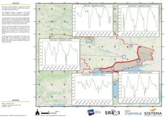
A pipeline generation to get and process images from Sentinel-2 for a specific ROI (Region of interest) to display and rescale NVDI values.


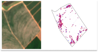
Automatic detection of in-field weeds using super-resolved Sentinel-2 at 1m per pixel imagery and delineated field boundaries.

The main sources of potential pollution during armed conflicts are usually heavy industrial sites and critical infrastructure that, when damaged, could result in major chemical releases. Therefore, a useful starting point is to identify vulnerable locatio...
A Docker service to train segmentation models for Sentinel 2 patches.

North and Central Mali entail the country’s highest prevalence of vulnerable communes siting at the intersection of chronic vulnerability, food insecurity, and armed conflict. Humanitarian and development programs are faced with diverse challenges in the ...
