
Technical Categories
AI ethics
AI services
Business Category
Agriculture
Healthcare
Maritime Sector
Public Services
Regional Engagement - DIHs
Organisation type
Association
DATAlife
The Maritime sector is defined as consisting of the individual shipping, ports, marine and maritime business services industries, each of which comprise a diverse array of activities.

EnvClus* is an unsupervised data-driven framework that forecasts the most probable realistic and smooth trajectory from a given query position of a vessel (entire route or underway forecasting) towards its destination port.
Digital twins serve as virtual representations of physical environments that are increasingly valuable across various sectors, including maritime operations. The complexity of monitoring vessel traffic through the Automatic Identification System (AIS), de...


Join the AUTOASSESS Webinar and discover how you can benefit from the Open Call for Tech Solutions.

The AUTOASSESS project is inviting startups and SMEs to present innovative technology solutions addressing specific use-case challenges, related to the development of the AUTOASSES solution: a system that leverages AI and Robotics for safe vessel inspecti...

Up to €100€ per Startup/SME selected


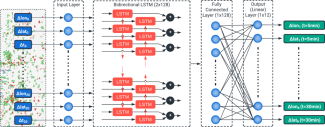
The development of solutions and models for the analysis, early detection and mitigation of vessel collision events is a significant step towards ensuring future maritime safety. In this context, a synthetic vessel proximity event dataset is created using...


Good practice usage guides about the baseline technology of the iMagine AI platform
Good practice usage guides about the baseline technology of the iMagine AI platform