Technical Categories
AI services
Machine learning
Business Category
Cloud, Edge and Infrastructure
Earth Observation
Energy
Organisation type
Company
GECOsistema Srl
AI4Copernicus is a European H2020 project that aims to bridge Artificial Intelligence (AI) with Earth Observation (EO) world by making the already developed AI4EU AI-on-demand platform, the digital environment of choice for users of Copernicus data, for researchers and innovators.
AI4Copernicus aims to bridge Artificial Intelligence (AI) with Earth Observation (EO) world by making the AI4EU AI-on-demand platform the platform of choice for users of Copernicus data along the value chain (scientists, SMEs, non-tech sector).
AI4Copernicus will achieve this by exposing AI4EU resources on EO data (DIAS – data and information access services) platforms, making it easy to procure computing power and large EO data, as well as to access training material and expertise.
AI4Copernicus proposes to reinforce and optimise the AI4EU platform service offering with AI4Copernicus datasets, tools and services relevant to Copernicus data to facilitate the use and uptake of the platform resources in domains of high economic and societal impact, such as in Agriculture, Health, Energy and Security.
A series of 4 open calls will be implemented, leading to 8 small-scale experiments (smaller, single-beneficiary experimental projects targeting technology-advanced users) and 9 use-cases (larger-budget projects, involving at least one non-technology user). The open calls will necessitate the utilisation of DIAS platforms, Copernicus data, the AI4EU platform and the services and resources that will be provided by the AI4Copernicus project.
Through organising, facilitating and mentoring these Open Calls, AI4Copernicus will reach out to new user domains and boost the use of the AI4EU platform. More specifically, AI4Copernicus aims to:
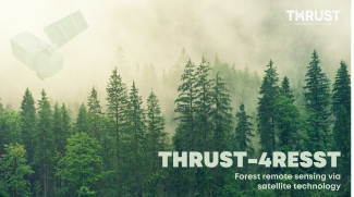
THRUST-4RESST is a multifunctional forest condition assessment tool that is based on AI-aided analytics of time-resolved satellite data
AQQA was an AI4Copernicus micro-project, selected in the 5th round of open calls. It aimed to test a language-based interaction with air quality data by making use of linked geospatial data tools and the health bootstrapping service provided by the AI4Cop...


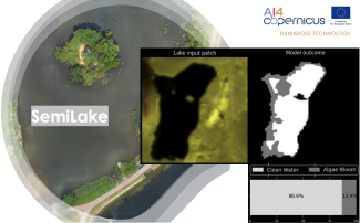
We introduce SemiLake, a semi-supervised representation learning-powered urban lakes and algae monitoring system.
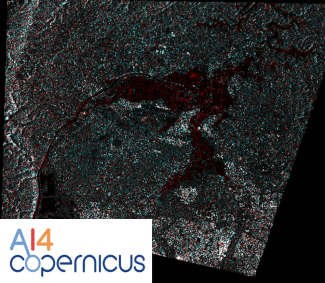
The Security Bootstrapping services and resources have been developed in order to support the AI4Copernicus project’s open calls by reducing the time and resources of the bidders in the data preparation and allowing them to focus on the development of inn...
The Security Bootstrapping services and resources have been developed in order to support the AI4Copernicus project’s open calls by reducing the time and resources of the bidders in the data preparation and allowing them to focus on the development of inn...
The Security Bootstrapping services and resources have been developed in order to support the AI4Copernicus project’s open calls by reducing the time and resources of the bidders in the data preparation and allowing them to focus on the development of inn...
The Security Bootstrapping services and resources have been developed in order to support the AI4Copernicus project’s open calls by reducing the time and resources of the bidders in the data preparation and allowing them to focus on the development of inn...
The Security Bootstrapping services and resources have been developed in order to support the AI4Copernicus project’s open calls by reduce the time and resources of the bidders in the data preparation and allowing them to focus on the development of innov...
The model was designed for tree-crops semantic-segmentation and created using the AI4Copernicus service: “Deep network for pixel-level classification of S2 patches"

The dataset was designed for semantic-segmentation-based deep learning models and utilized in the AI4Copernicus service: “Deep network for pixel-level classification of S2 patches" in which a U-net neural network was used in order to create an AI model fo...
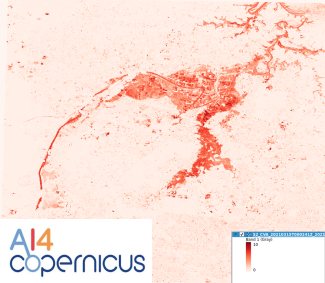
The dataset was designed for prediction of vegetation health on Sentinel-2 imagery and utilized in the AI4Copernicus service: “Long Short-Term Memory Neural Network for NDVI prediction" in which an LSTM neural network was trained in order to create an AI ...
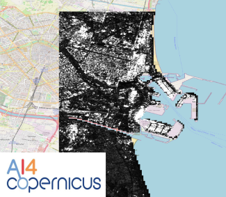
Pixel-level classification model, using the pixel-level classification bootstrapping service of AI4Copernicus project
Pixel-level classification model, using the pixel-level classification bootstrapping service of AI4Copernicus project
Pixel-level classification model, using the pixel-level classification bootstrapping service of AI4Copernicus project
Pixel-level classification model, using the pixel-level classification bootstrapping service of AI4Copernicus project
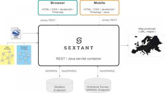
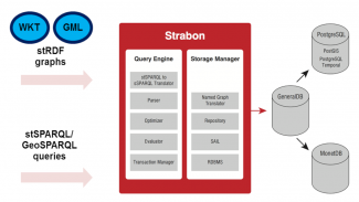
A web-based and mobile ready platform for visualizing time-evolving linked geospatial data.
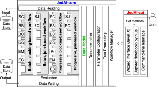
The Force Behind Entity Resolution. Perform State Of The Art Entity Resolution With The Java Generic Data Integration Toolkit.
This service is focused on Long Short-Term Memory Neural Networks for classification and prediction of NDVI values on Sentinel-2 image time series. This service provides trainable models for the crop type mapping task and the prediction, and a pre-trained...
The sercvice is focused on the production of monthly composites for agronomical time series of Sentinel-2 images. One of the challenges of crop type mapping at large scale is the definition of a regular temporal sampling grid to perform analysis in a stan...
The Security Bootstrapping services and resources have been developed in order to support the AI4Copernicus project’s open calls. The development of these bootstrapping services aimed to reduce the time and resources of the bidders in the data preparation...
The Agriculture Bootstrapping services and resources have been developed in order to support the AI4Copernicus project’s open calls. The development of these bootstrapping services aimed to reduce the time and resources of the bidders in the data preparat...