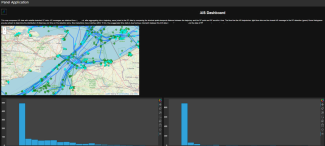
Vessel Traffic Flow Forecasting (VTFF) using Machine Learning Methods
Descriptions of the implementation of the Vessel Traffic Flow Forecasting (VTFF) model that forecasts the vessel traffic flow within a given region.
The Maritime sector is defined as consisting of the individual shipping, ports, marine and maritime business services industries, each of which comprise a diverse array of activities.
Descriptions of the implementation of the Vessel Traffic Flow Forecasting (VTFF) model that forecasts the vessel traffic flow within a given region.
An improved version of the core parts of the code that implements the Vessel Location Forecasting (VLF) and Vessel Route Forecasting (VRF) methods.
RF & OpenAIS Dashboard to allow users to quickly examine data without the need for custom software packages. This map compares AIS data with satellite-detected RF data.
Monitor the tracks of specific ships - confirm AIS positions and fill in the gaps from periods of dark activity, through machine-learning ship detections.
Monitoring of specific areas - unlock Maritime Domain Awareness through AI vessel detections and AIS-fusion.
Tools for extraction of numerical specifications from technical documentation in PDF format
Optimisation of the design and operation of ship energy systems in terms of energy efficiency and lifecycle costs
Model for port to port vessel route forecasting using massive Automatic Identification System (AIS) datasets
Automatic Identification System (AIS) dataset from the Mediterranean Sea
AIS dataset collected within a 24h period (starting from 29/02/2020 10PM UTC) from a single receiver located near the port of Piraeus (Greece)
An implementation of the DBSCAN algorithm,that extracts mooring places out of AIS messages. Package also includes methods to analyze extracted clusters.