Asset Type
Dataset
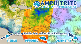
HIRES-CURRENT MED 2022
Dataset of High-Resolution Currents [2KM] in the Mediterranean Sea for the year 2022, produced during the project AI4Copernicus ODFuse4Ship.
Dataset of High-Resolution Currents [2KM] in the Mediterranean Sea for the year 2022, produced during the project AI4Copernicus ODFuse4Ship.
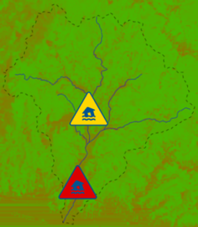
AI-RON MAN Wildfire Hazard Risk Assessment scheduled pipeline to continuously update Thermal Anomalies predictions
AI-RON MAN Wildfire Hazard Risk Assessment web application
Backend service of AI-RON MAN Wildfire Hazard Risk Assessment platform
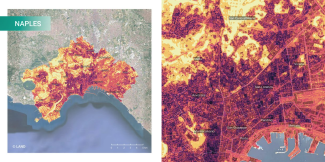
UrbAlytics aims to bridge Artificial Intelligence with Earth Observations, producing information layers that can support city planners and decision-makers in the context of climate resilience and related challenges in urban areas. This research investigat...
Frontend of EO4NOWCAST Near Real-Time Soil Moisture Assessment and Pluvial Flood Nowcasting services
Backend of EO4NOWCAST Near Real-Time Soil Moisture Assessment and Pluvial Flood Nowcasting services
- Generation of current Soil Moisture (SM) local maps based on the use of a ML model that processes ground-based precipitation measurements and Normalized Difference Moisture Index (NDMI) processed from the last available Copernicus S2 satellite tile. - ...
Agriculture productivity maps based on satellite images at the field level are revolutionizing the way farmers manage their crops. These maps provide detailed insights into the health and performance of individual fields, enabling farmers to make data-dri...
Agriculture productivity maps based on satellite images and machine learning algorithms have become powerful tools for understanding and optimizing agricultural practices. By combining the capabilities of satellite imagery and machine learning algorithms,...
TimeSen2Crop is a pixel based dataset made up of more than 1 million samples of Sentinel 2 Time Series associated to 16 crop types, during an agronomic year ranging from September 2017 to August 2018. The dataset contains atmospherically corrected samples...