
@ EU Copernicus - https://www.copernicus.eu
Earth observation plays a crucial role in supporting policy-making processes and developing some economic areas. A vast amount of earth observation data is collected that can feed AI models and methods and thus help to acquire new knowledge and develop innovative products. This section gives references on on-going projects and presents results in the area of AI in earth observation.
Datasets used to train a Deep Learning model for estimating the day-ahead wind speed at hourly basis. Developed by AMIGO s.r.l. for the ARIA project, part of the I-NERGY 2nd Open Call.
Introducing ESFA (Empirical Season Forecast for Agriculture) – your reliable companion in long-term agricultural planning. Our validated AI algorithms, which outperform other state-of-the-art climate prediction models, are at the core of ESFA's capabiliti...
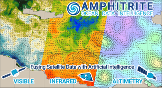
Dataset of High-Resolution Currents [2KM] in the Mediterranean Sea for the year 2022, produced during the project AI4Copernicus ODFuse4Ship.
AI-RON MAN Wildfire Hazard Risk Assessment scheduled pipeline to continuously update Thermal Anomalies predictions
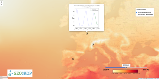
Discover one of the breakthrough achievements of the ESFA project, a pioneer project in the field of Artificial Intelligence applied to Climate Prediction. Leveraging Geoskop’s revolutionary AI algorithms, housed in a Docker image, we provide unprecedente...
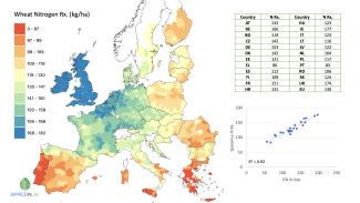
Farmers need cost-effective nitrogen (N) rate recommendations (Rx) in order to make better fertilisation decisions and comply with regulations while maintaining production. We provide district-based N rate Rx, allowing farmers and consultants to better un...
AI-RON MAN Wildfire Hazard Risk Assessment web application
Backend service of AI-RON MAN Wildfire Hazard Risk Assessment platform
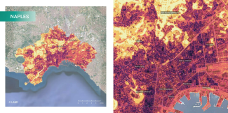
UrbAlytics aims to bridge Artificial Intelligence with Earth Observations, producing information layers that can support city planners and decision-makers in the context of climate resilience and related challenges in urban areas. This research investigat...
This dataset contains a set of georeferenced labels used in the LIVE4ENV project for training and evaluating an AI model for land-cover classification in livestock farms. It includes 3 classes: - 0: non-productive areas - 1: woodland - 2: pasture
Frontend of EO4NOWCAST Near Real-Time Soil Moisture Assessment and Pluvial Flood Nowcasting services