
@ EU Copernicus - https://www.copernicus.eu
Earth observation plays a crucial role in supporting policy-making processes and developing some economic areas. A vast amount of earth observation data is collected that can feed AI models and methods and thus help to acquire new knowledge and develop innovative products. This section gives references on on-going projects and presents results in the area of AI in earth observation.
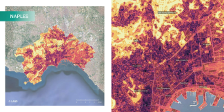
Backend service of AI-RON MAN Wildfire Hazard Risk Assessment platform
UrbAlytics aims to bridge Artificial Intelligence with Earth Observations, producing information layers that can support city planners and decision-makers in the context of climate resilience and related challenges in urban areas. This research investigat...
This dataset contains a set of georeferenced labels used in the LIVE4ENV project for training and evaluating an AI model for land-cover classification in livestock farms. It includes 3 classes: - 0: non-productive areas - 1: woodland - 2: pasture
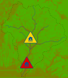
Frontend of EO4NOWCAST Near Real-Time Soil Moisture Assessment and Pluvial Flood Nowcasting services
Backend of EO4NOWCAST Near Real-Time Soil Moisture Assessment and Pluvial Flood Nowcasting services
This dataset contains corrected PM10 measurements for Sofia Jan-May 2022 fetched from Sensor Community and calibrated with an Extremely Randomised Tree.
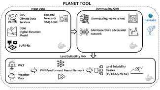
OPTIMAL for cOPernicus irrigaTION mAnagement tooLkit is a combination of state-of-the-art Machine Learning techniques that is designed to forecast environmental parameters which enable the delivery of irrigation needs intelligence. The model presented ...
AI E2O.GREEN AI assets pipeline for automated Golf and Grassland Monitoring through interactive maps and computer vision models based on Copernicus data and services.
Climate change, with its accompanying global warming and increasingly severe weather conditions, presents substantial risks to agricultural sustainability worldwide. This is driving the agri-food sector to adapt through the use of new technologies and str...
- Generation of current Soil Moisture (SM) local maps based on the use of a ML model that processes ground-based precipitation measurements and Normalized Difference Moisture Index (NDMI) processed from the last available Copernicus S2 satellite tile. - ...
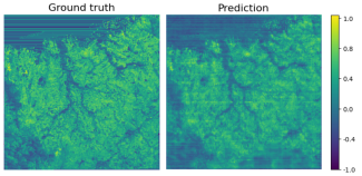
This asset contains the notebook of the AI model developed in the EO4NOWCAST project, which allows to estimate a current Soil Moisture Map starting from two inputs: - The most recent NDMI map available from Copernicus - The cumulative rainfall map