Asset Type
As a Service
VAKE OVERWATCH
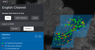
Monitoring of specific areas - unlock Maritime Domain Awareness through AI vessel detections and AIS-fusion.
AI4Copernicus is a European H2020 project that aims to bridge Artificial Intelligence (AI) with Earth Observation (EO) world by making the already developed AI4EU AI-on-demand platform, the digital environment of choice for users of Copernicus data, for researchers and innovators.
AI4Copernicus aims to bridge Artificial Intelligence (AI) with Earth Observation (EO) world by making the AI4EU AI-on-demand platform the platform of choice for users of Copernicus data along the value chain (scientists, SMEs, non-tech sector).
AI4Copernicus will achieve this by exposing AI4EU resources on EO data (DIAS – data and information access services) platforms, making it easy to procure computing power and large EO data, as well as to access training material and expertise.
AI4Copernicus proposes to reinforce and optimise the AI4EU platform service offering with AI4Copernicus datasets, tools and services relevant to Copernicus data to facilitate the use and uptake of the platform resources in domains of high economic and societal impact, such as in Agriculture, Health, Energy and Security.
A series of 4 open calls will be implemented, leading to 8 small-scale experiments (smaller, single-beneficiary experimental projects targeting technology-advanced users) and 9 use-cases (larger-budget projects, involving at least one non-technology user). The open calls will necessitate the utilisation of DIAS platforms, Copernicus data, the AI4EU platform and the services and resources that will be provided by the AI4Copernicus project.
Through organising, facilitating and mentoring these Open Calls, AI4Copernicus will reach out to new user domains and boost the use of the AI4EU platform. More specifically, AI4Copernicus aims to:
Monitoring of specific areas - unlock Maritime Domain Awareness through AI vessel detections and AIS-fusion.
Monitor the tracks of specific ships - confirm AIS positions and fill in the gaps from periods of dark activity, through machine-learning ship detections.
5 year dataset with information on when phenological states have been reached in 11 different plots in La Rioja - Spain.
A pipeline generation to get and process images from Sentinel-2 for a specific ROI (Region of interest) to display and rescale NVDI values.
The model developed called SLIDE for SateLlite Images prediction with Deep Learning is a combination of state-of-the-art AI techniques that is designed to forecast irradiance maps. It uses up to four satellite-derived irradiance maps in order to genera...
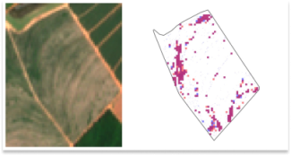
Automatic detection of in-field weeds using super-resolved Sentinel-2 at 1m per pixel imagery and delineated field boundaries.

North and Central Mali entail the country’s highest prevalence of vulnerable communes siting at the intersection of chronic vulnerability, food insecurity, and armed conflict. Humanitarian and development programs are faced with diverse challenges in the ...
- Generation of current Soil Moisture (SM) local maps based on the use of a ML model that processes ground-based precipitation measurements and Normalized Difference Moisture Index (NDMI) processed from the last available Copernicus S2 satellite tile. - ...
This dataset contains corrected PM10 measurements for Sofia Jan-May 2022 fetched from Sensor Community and calibrated with an Extremely Randomised Tree.
Backend of EO4NOWCAST Near Real-Time Soil Moisture Assessment and Pluvial Flood Nowcasting services
Frontend of EO4NOWCAST Near Real-Time Soil Moisture Assessment and Pluvial Flood Nowcasting services
Climate change, with its accompanying global warming and increasingly severe weather conditions, presents substantial risks to agricultural sustainability worldwide. This is driving the agri-food sector to adapt through the use of new technologies and str...
OPTIMAL for cOPernicus irrigaTION mAnagement tooLkit is a combination of state-of-the-art Machine Learning techniques that is designed to forecast environmental parameters which enable the delivery of irrigation needs intelligence. The model presented ...
This dataset contains a set of georeferenced labels used in the LIVE4ENV project for training and evaluating an AI model for land-cover classification in livestock farms. It includes 3 classes: - 0: non-productive areas - 1: woodland - 2: pasture
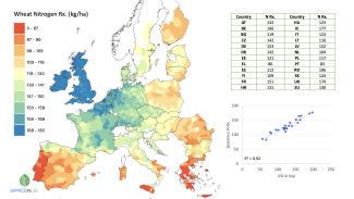
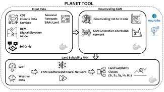
Farmers need cost-effective nitrogen (N) rate recommendations (Rx) in order to make better fertilisation decisions and comply with regulations while maintaining production. We provide district-based N rate Rx, allowing farmers and consultants to better un...
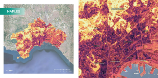
UrbAlytics aims to bridge Artificial Intelligence with Earth Observations, producing information layers that can support city planners and decision-makers in the context of climate resilience and related challenges in urban areas. This research investigat...
AI-RON MAN Wildfire Hazard Risk Assessment scheduled pipeline to continuously update Thermal Anomalies predictions
Backend service of AI-RON MAN Wildfire Hazard Risk Assessment platform
AI-RON MAN Wildfire Hazard Risk Assessment web application
Discover one of the breakthrough achievements of the ESFA project, a pioneer project in the field of Artificial Intelligence applied to Climate Prediction. Leveraging Geoskop’s revolutionary AI algorithms, housed in a Docker image, we provide unprecedente...
The main sources of potential pollution during armed conflicts are usually heavy industrial sites and critical infrastructure that, when damaged, could result in major chemical releases. Therefore, a useful starting point is to identify vulnerable locatio...
This service is focused on probabilistic downscaling (super-resolution) of CAMS model output. Current AC and AQ models output forecasts at relatively low resolution (e.g., ca. 10 to 40 km for the CAMS EU and global domains). This service generates high-re...
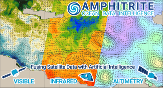
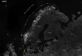
Dataset of High-Resolution Currents [2KM] in the Mediterranean Sea for the year 2022, produced during the project AI4Copernicus ODFuse4Ship.
Introducing ESFA (Empirical Season Forecast for Agriculture) – your reliable companion in long-term agricultural planning. Our validated AI algorithms, which outperform other state-of-the-art climate prediction models, are at the core of ESFA's capabiliti...
A Docker service to train segmentation models for Sentinel 2 patches.
TimeSen2Crop is a pixel based dataset made up of more than 1 million samples of Sentinel 2 Time Series associated to 16 crop types, during an agronomic year ranging from September 2017 to August 2018. The dataset contains atmospherically corrected samples...
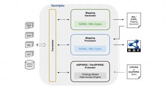
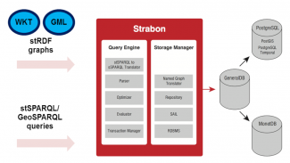
GeoTriples is a tool for transforming geospatial data from their original formats into RDF.
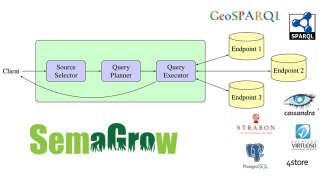
Semagrow is a SPARQL query federator of heterogeneous data sources.
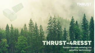
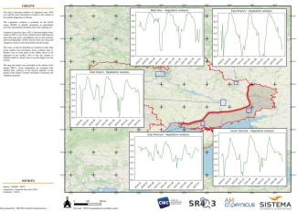
THRUST-4RESST is a multifunctional forest condition assessment tool that is based on AI-aided analytics of time-resolved satellite data
AQQA was an AI4Copernicus micro-project, selected in the 5th round of open calls. It aimed to test a language-based interaction with air quality data by making use of linked geospatial data tools and the health bootstrapping service provided by the AI4Cop...
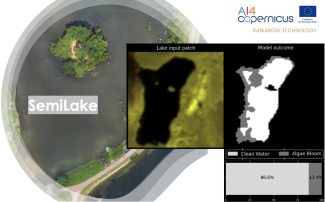
We introduce SemiLake, a semi-supervised representation learning-powered urban lakes and algae monitoring system.
The Security Bootstrapping services and resources have been developed in order to support the AI4Copernicus project’s open calls by reducing the time and resources of the bidders in the data preparation and allowing them to focus on the development of inn...
The Security Bootstrapping services and resources have been developed in order to support the AI4Copernicus project’s open calls by reducing the time and resources of the bidders in the data preparation and allowing them to focus on the development of inn...
The Security Bootstrapping services and resources have been developed in order to support the AI4Copernicus project’s open calls by reducing the time and resources of the bidders in the data preparation and allowing them to focus on the development of inn...
The Security Bootstrapping services and resources have been developed in order to support the AI4Copernicus project’s open calls by reducing the time and resources of the bidders in the data preparation and allowing them to focus on the development of inn...
The Security Bootstrapping services and resources have been developed in order to support the AI4Copernicus project’s open calls by reduce the time and resources of the bidders in the data preparation and allowing them to focus on the development of innov...
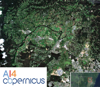
The model was designed for tree-crops semantic-segmentation and created using the AI4Copernicus service: “Deep network for pixel-level classification of S2 patches"
The dataset was designed for semantic-segmentation-based deep learning models and utilized in the AI4Copernicus service: “Deep network for pixel-level classification of S2 patches" in which a U-net neural network was used in order to create an AI model fo...
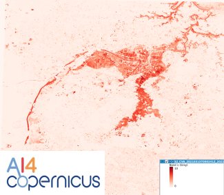
The dataset was designed for prediction of vegetation health on Sentinel-2 imagery and utilized in the AI4Copernicus service: “Long Short-Term Memory Neural Network for NDVI prediction" in which an LSTM neural network was trained in order to create an AI ...
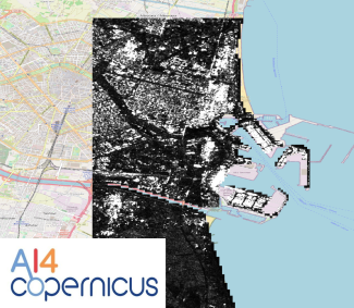
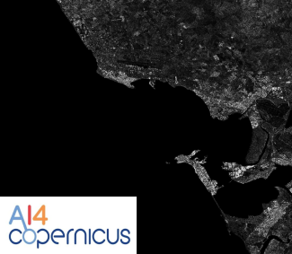
Pixel-level classification model, using the pixel-level classification bootstrapping service of AI4Copernicus project
Pixel-level classification model, using the pixel-level classification bootstrapping service of AI4Copernicus project
Pixel-level classification model, using the pixel-level classification bootstrapping service of AI4Copernicus project
Pixel-level classification model, using the pixel-level classification bootstrapping service of AI4Copernicus project
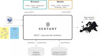
A web-based and mobile ready platform for visualizing time-evolving linked geospatial data.
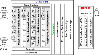
The Force Behind Entity Resolution. Perform State Of The Art Entity Resolution With The Java Generic Data Integration Toolkit.
This service is focused on Long Short-Term Memory Neural Networks for classification and prediction of NDVI values on Sentinel-2 image time series. This service provides trainable models for the crop type mapping task and the prediction, and a pre-trained...
The sercvice is focused on the production of monthly composites for agronomical time series of Sentinel-2 images. One of the challenges of crop type mapping at large scale is the definition of a regular temporal sampling grid to perform analysis in a stan...
The Security Bootstrapping services and resources have been developed in order to support the AI4Copernicus project’s open calls. The development of these bootstrapping services aimed to reduce the time and resources of the bidders in the data preparation...